
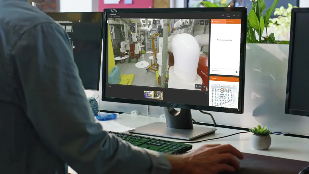
Point clouds are one of the most valuable outputs from reality capture, but they have not always been easy for every stakeholder to use. Architects, engineers, contractors, owners, and facilities teams may need the information inside a point cloud, but not everyone has specialized software or the technical background to navigate dense 3D data confidently.
That is the gap the Hexagon Multivista point cloud viewer helps close.
The point cloud viewer powered by Hexagon GeoCloud is an enhanced feature within 3D laser scanning and the broader Capture services experience. It allows users to move from measurable 360° laser scan imagery into the full 3D point cloud captured in the field, helping project teams navigate, view, and measure site conditions in a browser.
As Mark King, Senior Product Manager for Hexagon Multivista, explains:
“We’re now taking that to the next step, where not only are we able to view those measurable images, but we can actually jump out and navigate the full three-dimensional point cloud that’s captured in the field.”
Why easier point cloud access matters
3D laser scanning captures accurate site data that can support existing conditions documentation, renovation planning, as-built modeling, Building Information Modeling (BIM), 2D CAD documentation, and construction validation. The value of that data is significant, especially when teams need to understand what is in place before designing, coordinating, or making field decisions.
But access matters as much as capture.
A point cloud is one of the closest digital representations of captured site reality. When teams only review simplified outputs, such as a static image, CAD file, or model derived from the scan, they may not always have the full spatial context needed to answer a question. The point cloud gives teams a more complete view of captured conditions when they need to go back to the source.
If point cloud data is hard to open or limited to technical specialists, fewer stakeholders can use it directly. That can slow decisions, create extra handoffs, and reduce the value of the data already captured in the field.
The point cloud viewer helps make detailed 3D site data easier to access through a familiar browser-based experience. Users can still work with measurable 360° imagery, but they can also move into the surrounding 3D point cloud when they need more context.
Moving beyond fixed 360° photo locations
360° laser scan imagery remains a useful way to review captured spaces. Many users already understand this type of navigation because it feels familiar: move from image to image, look around, and inspect conditions from the scan location.
The limitation is that fixed image locations only show the site from specific points. When someone needs to understand something outside that scan’s position, the image alone may not answer the question.
The point cloud viewer adds another layer. Users can move from the 360° image into the point cloud itself. Once inside the 3D data, they can navigate more freely, move closer to the area they need to inspect, and understand conditions from a broader spatial perspective.
As Mark states:
“Wherever the picture was taken, that’s the only place you can go. Now that we’re going to the 3D point cloud, you can go wherever you want to go.”
For AECO teams, that flexibility can support practical questions: Is there enough clearance in this area? What does the existing room layout look like? How does this condition relate to the surrounding space? Can we take a quick check of the dimension before sending someone back to the field?
What can users do in the point cloud viewer?
The point cloud viewer is designed to make 3D laser scan data easier to navigate and use. Within the browser-based experience, users can:
- View measurable 360° laser scan imagery
- Move into the full 3D point cloud
- Walk around, fly through, rotate, pan, zoom in, and zoom out
- Measure between points in the 3D environment
- Multi-select points to define an area and create rough square footage or square meterage checks
Those area checks give teams a practical way to understand space, size, and context directly in the browser, especially when they need a quick reference before opening specialized software or returning to the site. The value is that users can get a practical sense of space, size, and context without immediately opening specialized software or requesting another site to visit.
Why floor plan navigation matters
One of the strongest parts of the point cloud viewer experience is how users enter the data. Instead of opening into a large, unfamiliar point cloud and searching for the right area, users can begin from a floor plan. They can choose the room, area, or scan position they understand, then move into the 3D point cloud from there.
That matters because floor plans are familiar to AECO stakeholders. By using the floor plan as the starting point, the point cloud viewer helps bridge the gap between familiar 2D navigation and more advanced 3D data.
Mark describes the value this way:
“Floor plans are kind of the currency of our industry. People tend to understand floor plans. So if you see a floor plan, you see some drop spots on it in terms of the positions where we’ve actually scanned, people naturally have an understanding of, ‘Okay, I want to go see this area of the floor plan.’”
That usability is important. Point clouds can be dense and intimidating for users who do not work in them every day. Floor plan navigation gives teams a simpler entry point, helping more stakeholders find the information they need.
Who benefits from easier point cloud access?
Architects, engineers, and designers can use scan data to understand current conditions before renovation, refurbishment, or adaptive reuse work begins. When scanning data supports scan to BIM or other Create services, easier point cloud access can also help teams review the physical context behind as-built models and documentation.
Construction teams can use captured scan data to understand what was in place at a specific time. That can support field coordination, issue review, quality conversations, and construction validation when teams need to see current conditions more clearly.
Owners, municipalities, school districts, and facilities teams can use the point cloud viewer to virtually access spaces across large building portfolios. For example, a facilities team may want to review a boiler room before sending a vendor on site, or a campus team may need to understand room types, layouts, or conditions across multiple buildings.
Conclusion
3D laser scan data is powerful, but access has often been the barrier. The Hexagon Multivista point cloud viewer helps reduce that barrier by giving project teams a more intuitive way to move from familiar 360° imagery and floor plan navigation into the full 3D point cloud.
By making point clouds easier to access in a browser, the point cloud viewer helps more stakeholders inspect conditions, take check measurements, understand spaces, and make better use of the reality capture data already collected through 3D laser scanning.
For AECO teams, that is the real value: not just more data, but more usable site context.
Ready to see how 3D laser scanning and the point cloud viewer can help your team access, navigate, and use captured site data more effectively? Book a free 30-minute consultation with our team to discuss existing conditions, renovation planning, construction validation, and downstream Create service opportunities.